 |
 |
 |
 |
 |
 |
 |
 |
 |
 |
 |
 |
 |
 |
 Previous Page

042616_YKMV_A9.pdf

Active Weather Pattern

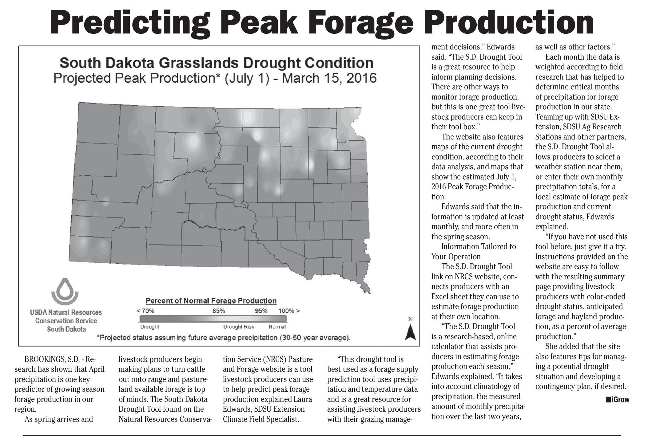
Predicting Peak Forage Production
shop online at www.missourivalleyshopper.com
April 26, 2016 • Page 9
Predicting Peak Forage Production
BROOKINGS, S.D. - Research has shown that April
precipitation is one key
predictor of growing season
forage production in our
region.
As spring arrives and
livestock producers begin
making plans to turn cattle
out onto range and pastureland available forage is top
of minds. The South Dakota
Drought Tool found on the
Natural Resources Conserva-
tion Service (NRCS) Pasture
and Forage website is a tool
livestock producers can use
to help predict peak forage
production explained Laura
Edwards, SDSU Extension
Climate Field Specialist.
“This drought tool is
best used as a forage supply
prediction tool uses precipitation and temperature data
and is a great resource for
assisting livestock producers
with their grazing manage-
ment decisions,” Edwards
said. “The S.D. Drought Tool
is a great resource to help
inform planning decisions.
There are other ways to
monitor forage production,
but this is one great tool livestock producers can keep in
their tool box.”
The website also features
maps of the current drought
condition, according to their
data analysis, and maps that
show the estimated July 1,
2016 Peak Forage Production.
Edwards said that the information is updated at least
monthly, and more often in
the spring season.
Information Tailored to
Your Operation
The S.D. Drought Tool
link on NRCS website, connects producers with an
Excel sheet they can use to
estimate forage production
at their own location.
“The S.D. Drought Tool
is a research-based, online
calculator that assists producers in estimating forage
production each season,”
Edwards explained. “It takes
into account climatology of
precipitation, the measured
amount of monthly precipitation over the last two years,
as well as other factors.”
Each month the data is
weighted according to field
research that has helped to
determine critical months
of precipitation for forage
production in our state.
Teaming up with SDSU Extension, SDSU Ag Research
Stations and other partners,
the S.D. Drought Tool allows producers to select a
weather station near them,
or enter their own monthly
precipitation totals, for a
local estimate of forage peak
production and current
drought status, Edwards
explained.
“If you have not used this
tool before, just give it a try.
Instructions provided on the
website are easy to follow
with the resulting summary
page providing livestock
producers with color-coded
drought status, anticipated
forage and hayland production, as a percent of average
production.”
She added that the site
also features tips for managing a potential drought
situation and developing a
contingency plan, if desired.
niGrow
Active Weather Pattern Ahead
BROOKINGS, S.D.
- Warmer than average
temperatures are forecast to
continue through May and
the next few months, according to a National Oceanic
Atmospheric Administration’s (NOAA) April 21, 2016
Climate Prediction Center
Outlook.
“The national climate
outlook takes into account
long-term trends in temperature and precipitation,
seasonal climatology, com-
puter models and expertise
of forecasters in NOAA,”
explained Laura Edwards,
SDSU Extension Climate
Field Specialist.
She added that the
early part of 2016 has been
dominated by warmer than
average temperatures. Since
the first of the year, temperatures across the state are 2
to 8 degrees above average.
The NOAA climate outlook indicates an increased
likelihood of warmer than
average temperatures in
northern South Dakota in
May.
For the season ahead,
May through July, there is increased likelihood of warmer
than average temperatures
across the entire state.
Recent Moisture will
Benefit Farmers
As far as precipitation,
the year so far has been a
mixed bag, with some areas
receiving much more precipitation than others.
MV Shopper
M I S S O U R I VA L L E Y
“The last week has been
especially wet through central South Dakota, but much
of the far northeast and the
Black Hills are still below
average since January 1,”
Edwards said.
The outlook for precipitation shows equal chances of
below average, near average
and above average rainfall
for May through July. “There
is a large area just to the
south that is more likely to
be wetter than normal, so
there may be some opportunity to get some good storms
that tap into the moisture
from the south, such as we
saw this last week,” Edwards
said.
Edwards added that
before last weekend, there
had been some growing
concern about drought conditions setting in, especially
in northern South Dakota.
“Fortunately, the recent
rains have alleviated much
of that concern,” she said.
“The 2-inches or more that
much of the state received
RCR
POLLED
HEREFORDS
came at a good pace as was
able to effectively soak into
the soils.”
Edwards said that there
was not much runoff or
flooding, except in some
localized areas.
“These improvements
in soil moisture will be of
great benefit as area farmers
transition from small grains
planting to corn in the coming weeks,” she said.
For some of our corn
growing area, soil temperatures have not yet reached
the recommended 50 degree
threshold for planting.
Because of this, Edwards
said some period of warmer
weather will be needed to
increase soil temperatures
to reach the ideal conditions
for corn planting.
Water supplies for
livestock appear to have
had some recovery as well.
“The recent wet weather
has helped refill stock water
supplies,” she said. As a
result of these reduced water concerns and improve-
ments in soil moisture, the
U.S. Drought Monitor this
week eliminated most of the
abnormally dry conditions
through the central part of
the state.
Even though the outlook
for May shows warmer
than average temperatures
favored across the northern
tier of South Dakota, the
nearer term forecast shows
near average or cooler temperatures for the next week
or two.
Edwards said the shorter
term outlook for the next
two weeks shows an active
weather pattern returning
to the region. “This means
more chances of rainfall
across the area after our
brief period of warm and dry
weather,” she said.
Winter wheat and other
small grains could also benefit from the active weather
pattern. There may be some
delay in corn planting and
other field activities again as
wetter weather returns.
niGrow
REG POLLED HEREFORD BULLS AND PUREBRED F1 BLACK BALDY BULLS
YANKTON LIVESTOCK • FRIDAY, APRIL 29TH at 11 AM
Raising
RCR POLLED HEREFORDS
JAMES & BONNIE SIMMERMON AND SONS
38372 291ST STREET • LAKE ANDES, SD 57356
PHONE 605-487-7406 • CELL 605-481-1936
Polled Herefords
Since 1978
BULL SALES ARE COMING UP
Be sure to get your advertising in!
CLASSIFIEDS
IN PRINT
and ONLINE
To place your ad call...
605.665.5884
or drop by at 319 Walnut St.
www.missourivalleyshopper.com
Contact a marketing representative at the
MV Shopper
MV Shopper
M I S S O U R I VA L L E Y
319 Walnut Street • Yankton, SD 57078
605-665-5884 • 800-743-2968
M I S S O U R I VA L L E Y
Fax: 605-665-0288
www.missourivalleyshopper.com